Wednesday 17 September
Chirnside Park Cire Community Hub, 9.00am - 5.00pm
Council is committed to creating a transport network where everyone can safely move around and get to where they need to be, whether you walk, cycle, or drive.
In March 2025, we asked the Chirnside Park community to share what makes their neighbourhood a great place to walk and cycle, and what Council can do to make it even better. Through our interactive online mapping tool and conversations with locals, we received over 260 submissions filled with insights and suggestions. Check out the Engagement Report to read more about what the community had to say.
We reviewed the feedback alongside traffic and safety data to shape concept plans that respond to key issues raised during the initial consultation. The draft concept plans (collectively referred to as the draft Local Movement Plan) included proposals to adopt safer speed limits on local neighbourhood roads, adding traffic calming treatments, connecting missing links, and providing safe places to cross the street in busy areas.
We checked back with the community to see if the proposed treatments would enhance their walking and cycling experience in Chirnside Park and received over 90 comments on the draft Local Movement Plan. Navigate the tabs below to read more about how the project progressed.
Chirnside Park is a neighbourhood known for its distinctive charm and its role as a key activity centre in the Yarra Ranges. Fast-paced development over the past decade has enhanced activity and liveliness in the area, but it has also introduced challenges for the local community. An example of this is the safety impacts of more vehicles on local roads and their high travel speeds.
We have been investigating how we can address these impacts and make walking and cycling safer for the community, while also planning ahead to make sure we don’t face the same issues as the area continues to grow.
Thanks to everyone who had their say on the initial concept plans!
We've updated the plan to reflect the feedback shared during consultation.
You can review the list of projects here.
We received over 90 submissions about the draft Local Movement Plan during the second engagement.
Highlights are as follows:
Council has carefully considered the feedback received and the suggestions align closely with the concepts that were explored as part of the project. While a range of feedback about the types of treatments and locations were received, there is a need to balance these aspirations with practical considerations like design and construction costs, feasibility, and long-term maintenance.
Projects with allocated funding will be scheduled for construction. Residents directly affected by the works will be notified at the time of construction.
For projects yet to be funded, Council will explore funding opportunities and advocate for their detailed design and delivery.
Chirnside Park Cire Community Hub, 9.00am - 5.00pm
Belsay Reserve Chirnside Urban Park, 11.00am - 1.00pm
Chirnside Park Shopping Centre, 9.00am- 7.00pm
Chirnside Park Cire Community Hub, 9.00am - 5.00pm
As a result of the initial consultation, we developed concept plans which were presented to the community.
While we’ve carefully considered all comments, it’s not always possible to act on every concern. To ensure we make the best use of Council's resources, we need to focus on actions where we can deliver the biggest community benefit. While other locations may not warrant immediate action, they remain on our radar for future consideration as priorities evolve.
Several factors played a role in narrowing down the priority locations and proposed actions, including:
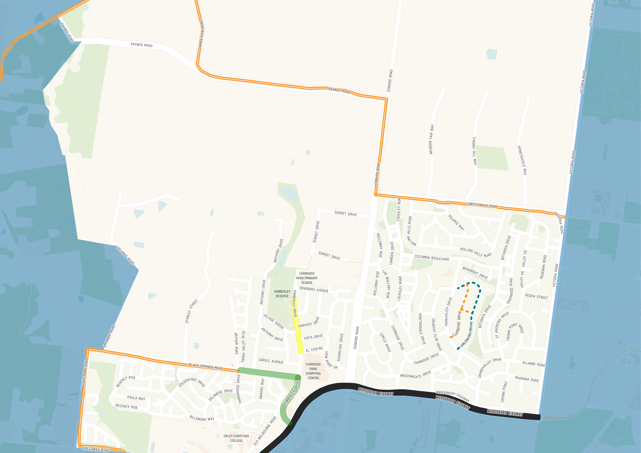
Green = completed projects, Blue = works in progress, and Orange = proposed projects.
Council understands how important footpaths are - they help people walk safely and give kids a chance to learn how to ride their bikes with confidence. Many streets in our neighbourhoods were built during a time when footpaths weren’t seen as necessary, which now makes getting around harder than it should be. Council is working to fix that by building new paths on at least one side of every road.
To achieve this, a footpath prioritisation framework is in place to assist Council in fairly and effectively delivering footpaths across the Shire to prioritise the many requests which Council receives across the municipality. Due to limited funding, only a small number of footpaths can be constructed each year.
Within Council’s Capital Works Program, funding for the construction of a footpath along Kingswood Drive has been allocated in 2025/26 and footpaths along Parkla Brae and Clubpoint Drive are being scoped and will be recommended for funding in future years.
Other footpath requests received during the first community consultation have been recorded and tagged for consideration for future footpath construction to increase the network. We’ll keep the community informed as we plan and schedule upcoming footpath projects in the area, in accordance with the prioritisation program.
The following shared paths within the study area are listed within the Draft Paths and Trails Plan:
To make it safer and easier to cross busy roads, we have proposed refuge islands and improvements at the following locations:
We heard from your feedback that speeding is one of the main things that make our streets feel unsafe. Many have raised how challenging it has become to simply cross the road and get to places just across the street, with so many vehicles and the fast speeds they travel at.
A key area that was highlighted is the Belsay Reserve Chirnside Urban Park – a place where kids play, families gather, and locals and visitors come to enjoy. Other busy areas that people want to become safer are paths to the Shopping Centre, Kimberley Reserve, and Chirnside Park Primary School.
Everyone deserves to move around our streets safely – whether you choose to walk, cycle, or drive. That’s why we’re working with the Department of Transport and Planning (DTP) to introduce safer speed limits of 50km/h on these roads:
Lower speeds, especially near parks, schools, and shops, make a big difference by helping reduce the risk of accidents and making it easier for everyone to move around safely.
We’re also looking to trial an expanded 40km/h zone to cover more of the busy areas — giving safer, more connected access to the shopping and recreation precincts. This proposed trial would run along Kimberley Drive, from the current 40km/h zone near Chirnside Park Primary School all the way to El Centro.
The safer speed zones will be supported by safer crossing points and a raised platform (speed table) along Kimberly Drive between Harvest Drive and Glendale Drive.
In addition, further speed treatments are proposed to encourage safer driving behaviours on our local roads:
The proposed speed zone changes are subject to approval of DTP.
Busier roads such as Edward Road, Switchback Road, and Maroondah Highway will need to be investigated further and addressed separately as these roads impact services and traffic movements beyond our local road network.
Feedback around on-street parking have been investigated, and changes have been endorsed in locations where warranted.
We recognise the importance of maintaining and keeping facilities in good shape so that they continue to be safe and useful to the community.
We continue to refine our systems and processes to manage our assets and stay ahead of wear and tear (where possible) and to address maintenance requests in a timely manner.
Footpaths and crossings: Many comments emphasised the need for more footpaths and pedestrian crossings particularly on routes to schools, parks, and the shopping centre.
Cycling paths: Suggestions included a bike path or a shared path along Black Springs Road and Switchback Road, as well as cycling route connections to Lilydale.
Speed management: Numerous comments called for speed humps, reduced speed limits, and other traffic calming measures to address speeding vehicles, especially in residential areas and around schools and bus stops.
Dangerous intersections: Several intersections were identified by commenters as hazardous.
Issues with on-street parking, especially near bends and intersections, were frequently raised.
We heard of the need for better pram and wheelchair access, including ramps and smoother transitions between footpaths and roads.
The call for better maintenance of existing footpaths, roads, and public spaces, including addressing issues like potholes and overgrown vegetation.
For more details of each theme, and who we heard from, check out our Engagement Report.
Add markers below to identify issues and opportunities for Chirnside Park traffic management.
The team will be out and about in Chirnside Park while the consultation is open
Click the follow button at the top of the page to stay updated on this project.
You will need to sign up to Shaping Yarra Ranges, but then we can keep you in the loop with updates and opportunities to be involved in this project.
Please note that our team is unable to respond to individual comments.
If you'd like to talk to us directly, please contact the Special Engineering Projects team via the details on this page "Contact us". You are also welcome to come and meet with us, when we're out and about in Chirnside Park (see "Come and chat to us" above).
| Current Conditions | Signed speed zones | ||
| Existing footpaths | (all other roads are 50kmh) | |
| Existing roundabouts |
| 40km/h |
| Existing raised intersections |
| 60km/h |
| Existing road humps |
| 70km/h |
| Existing traffic signals |
| 80km/h |
| Issues under investigation | ||
| Proposed projects | Out of scope roads | ||
| Proposed footpaths |
| Managed by Department of Transport and Planning |
| Proposed shared path | ||
| Proposed speed management projects |
Local Movement Plans focus on slowing traffic down to reduce the negative impacts of traffic in our communities and improving walking and cycling networks to encourage active travel. Local Movement Plans can involve making physical changes to the road and its surroundings (e.g. putting speed humps, connecting walking and cycling paths) or implementing new rules to encourage safe behaviours (e.g. pedestrian zones, speed limits).
Pathways designed for pedestrians, typically about 1.5 metres wide. They are commonly found in residential areas, parks, and urban landscapes. Footpaths are essential for promoting safe and convenient walking within communities, connecting residential areas to amenities like schools, parks, and public spaces.
Pathways designed to be shared by multiple user groups for activities such as walking, jogging, and cycling. Shared paths are typically wider than footpaths, ranging from about 2m to 4m.
A type of circular intersection. Instead of simply going through or turning left/right, vehicles travel around a circular central island in a clockwise direction until they reach the road they want to turn onto. Roundabouts improve safety by reducing the number of traffic conflict points and encouraging drivers to enter the intersection slowly and navigate mindfully.
Raised portions of road pavement meant to slow vehicles down. They come in different forms and can be curved bumps on the road, flat-top road humps (also called raised tables or raised platforms), or speed cushions (flat-top humps with cutouts to let bicycles and buses pass freely).
Road humps have line markings to warn drivers to slow down. Raised platforms and speed cushions usually have a different surface material to stand out from the rest of the road.
Similar to raised platforms but cover larger areas to let vehicles to come up fully on the platform (as opposed to humps that only bring up one set of wheels at a time, which results to a jolting motion).
Raised intersections slow vehicles down and also acts as a form of ‘threshold treatment’ to let drivers know that they are entering or leaving a different road environment (for example, from low traffic to higher traffic roads).
Pedestrian refuge islands are raised sections in the middle of the road that provide a safe place to pause when crossing. This allows pedestrians and cyclists to cross one part of the road at a time, which is especially helpful when crossing wide or busy roads.
Threshold treatments are colours and/or textures (brick, cobblestone, stamped concrete) that we add on some portions of our roads to create contrast with the rest of the road. These treatments serve as boundaries and signify a change in driving environment (e.g. different speeds, volumes, pedestrian traffic, activity) and are meant to alert drivers to adjust their driving behaviour accordingly.
Timeline item 1 - complete
Consultation 1 - Initial community feedback
Understanding what makes Chirnside Park a good place to walk and cycle, and how we can make it better.
March - April 2025
Timeline item 2 - complete
Develop initial concept plans
Investigate feedback and develop Local Movement concept plans to create a safer and better experience.
Timeline item 3 - complete
Consultation 2 - Concept plan consultation
Draft Local Movement concept plans open for community feedback.
September - October 2025
Timeline item 4 - complete
Review feedback & finalisation of plan
October - November 2025
Timeline item 5 - active
Construct funded projects
From November 2025 onwards
Timeline item 6 - active
Further design and applying for funding for other projects
Developing detailed designs and exploring ways to obtain funding for projects yet to be funded.
From December 2025 onwards
For other roads, eg Maroondah Hwy, please contact VicRoads
To report a hoon, please contact Crime Stoppers Victoria
| Name | Special Engineering Projects |
|---|---|
| Phone | 1300 368 333 |
| mail@yarraranges.vic.gov.au | |
| In writing | PO Box 105, Lilydale Vic 3140 Att: Special Engineering Projects |
If you need assistance when contacting Council, please use the numbers below.
![]()
Yarra Ranges Council acknowledges the Wurundjeri and other Kulin Nation peoples as the Traditional Owners and Custodians of these lands and waterways. We pay our respects to all Elders, past, present, and emerging, who have been, and always will be, integral to the story of our region. We proudly share custodianship to care for Country together.


